

 Meadow Green
How AI Can Keep P&C Insurers Profitable
How can P&C insurers remain profitable in 2024?

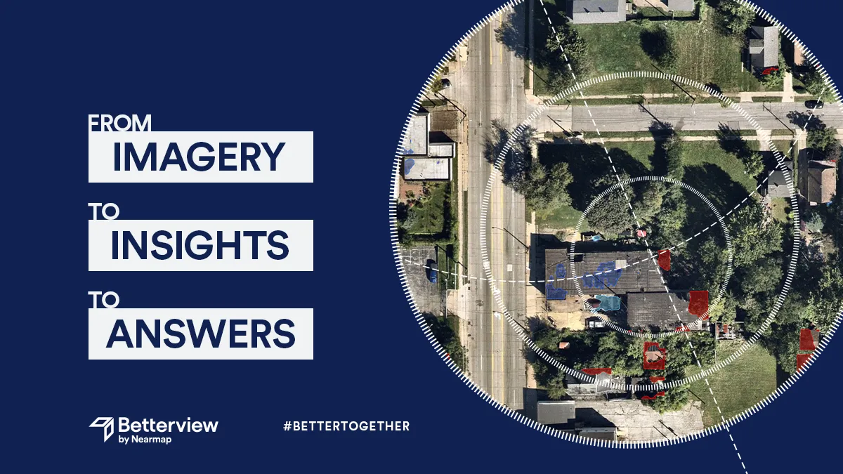
Introducing the latest addition to the Betterview Remote Property Intelligence platform: Defensible Space. This new feature includes a color-coded Defensible Space map and additional analytics housed in a dedicated Defensible Space Drawer within our UI.
This feature offers many benefits to insurers and policyholders alike. As defined by CalFire, Defensible Space is “the buffer you create between a building on your property and the grass, trees, shrubs, or any wildland area that surround it.” Maintaining Defensible Space is crucial for preventing fire damage, as well as losses from wind and hurricane damage. By providing a clear, transparent view of Defensible Space, the Betterview platform empowers insurers to take decisive actions to prevent future losses, lower their expenses, and keep customers safe.
How exactly does Betterview’s Defensible Space solution work, though? And does maintaining Defensible Space actually help to prevent damage? To answer both these questions, we will look at two properties that demonstrate the advantages of maintaining sufficient Defensible Space – as well as the dangers of not doing so.
 .
. 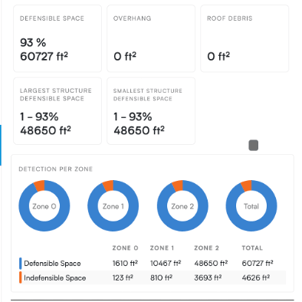
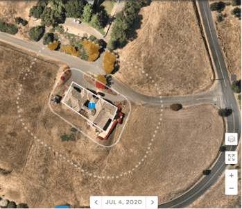
The first of the two properties (both are in the same area of California) has sufficient Defensible Space in all three surrounding zones. There is a minimal amount of trees, shrubs, and debris, all of which can contribute to a higher risk of damage. Overall, this property has 93% Defensible Space. The image above was taken before a major wildfire event. Let’s take a look at the property following the fire.
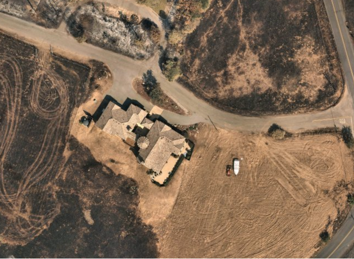
As can be seen, the surrounding area and vegetation experienced severe damage from the wildfire. The structure itself, however, appears largely intact from an aerial view. Defensible Space is probably not the only factor that helped protect this property, but it undoubtedly played a major role in keeping damage to a minimum. Now, let’s see how a different property in the same area fared, one with far less Defensible Space.
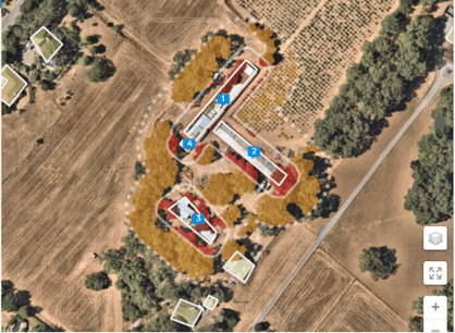
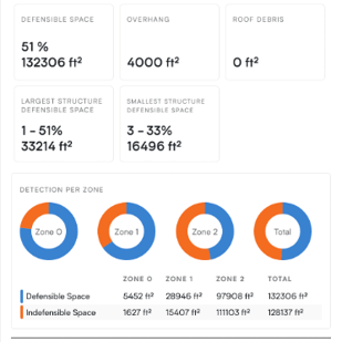
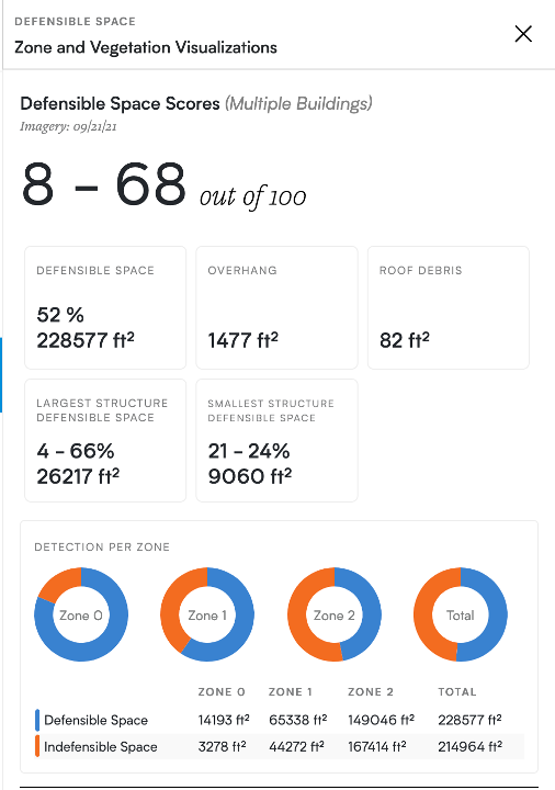
From the map alone, it should be clear that this property has far less Defensible Space. Multiple orange and red spotlights indicate that these areas are Indefensible, increasing the risk of damage (here, the spotlights are mostly trees.) As the drawer shows, the property only has 51% Defensible Space in total. While Zone 0 (the area closest to the property) has a higher percentage of Defensible Space, it is still far less than the first property. Let’s see how this property fared during the same wildfire.
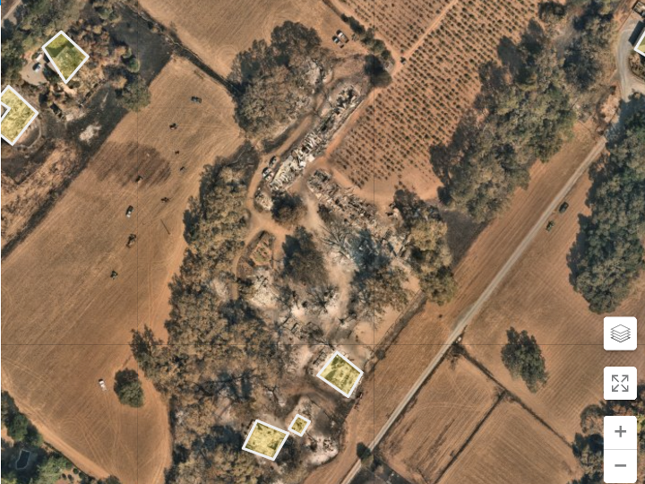
The results, perhaps predictably, were devastating. From an aerial view, all four structures on the property appear to have been completely destroyed by the fire. The loss is tragic, in no small part caused by a lack of sufficient Defensible Space.
It should be reiterated that Defensible Space is never the whole story when it comes to avoiding or experiencing damage from a catastrophic weather event. There are multiple other factors to consider, including overall property condition, and the path of the CAT event. All of these factors and more need to be considered when determining a property’s level of risk.
That is why Betterview’s Defensible Space solution is best seen as an additive to our platform. It is meant to be used alongside all the other Betterview features. These include our Roof Spotlight Index, grading every roof from 1-100; our trusted Partner Connect, where users can select from a library of third-party property intelligence to bolster their understanding of property condition and risk; and PropertyAction, which allows users to create customizable flags so they can prioritize properties that need the most attention.
Combined together, all of these features can help underwriters to predict & prevent damage from CAT events. For example: using PropertyAction, an underwriter could flag every property with less than 50% Defensible Space. They could then cross-reference this list with Partner Connect, selecting only properties in a zone with a high frequency of wildfires. With this list of properties assembled, they could then notify policyholders directly that they need to improve their Defensible Space, perhaps by trimming back their trees. The result is a win-win: insurers can underwrite a more solid risk, and the insured gets to sleep more soundly knowing they have an extra layer of security.
Betterview is committed to helping all P&C insurers predict and prevent losses, drive down expenses, and build a better customer experience. To learn more about Defensible Space, and to request a demo today, visit our Defensible Space page!
How can P&C insurers remain profitable in 2024?
What does the Nearmap acquisition of Betterview mean for the insurance industry?

The insurance industry, and the technology that supports it, have seen significant change over the last few years. New technology continues to come...